Off the Beaten Path in the Southwest: Active Adventures Along Utah’s Scenic Highway 12
- Ruth Bergman

- Sep 12, 2025
- 13 min read
A week of biking and hiking along Scenic Highway 12, exploring hoodoos, natural arches, hidden bridges, and desert waterfalls.
The Journey Continues
After a week of slot canyons, desert lakes, and sculpted red rock around Zion and Page, we turned the car north and set our sights on Scenic Highway 12 — a stretch of road often called one of the most beautiful drives in America.
Here, the landscape shifts again. Towering sandstone cliffs give way to rolling slickrock, painted hoodoos rise from hidden amphitheaters, and delicate bridges hide deep within twisting canyons. Every bend in the road reveal another vista, another impossible shape carved by time and water.
We thought we’d already seen the best of the Southwest, but Scenic Highway 12 held many surprises in store. Over the next seven days, we would find ourselves biking along ridgelines, wandering through whispering slot canyons, cooling off beneath desert waterfalls, and scrambling across slickrock to stand beneath natural arches.
If Part One was about heat and hidden canyons, this next chapter would be about big horizons, quiet surprises, and active days in the high desert.


A Warm-Up Ride with Big Views: Biking Utah's Red Canyon
We based ourselves at Ruby’s Inn, a century-old lodge and motel right outside Bryce Canyon National Park — an icon in its own right, steeped in history and perfectly placed for exploring this corner of Utah.
In my research, I’d read that Highway 12 is one of America’s most scenic drives, officially designated an All-American Road. While riding the entire highway was not in the cards for us, we decided to sample one of its most spectacular stretches: Red Canyon.
From Ruby’s, we rolled straight onto the bike path that connects the start of Highway 12 with Bryce Canyon. There’s no navigation needed here — just pedal, look up, and enjoy the scenery.
The first dozen kilometers are easy riding: a mostly flat stretch past ranches and through a small town whose name we didn’t even catch. The pavement has a few cracks that keep you alert, but it’s peaceful pedaling. Then, the landscape transforms. Red cliffs rise on both sides, and the path drops into the heart of Red Canyon. The descent is steep and fast, the hoodoos blurring past in flashes of orange and cream.
Some landmarks demand a stop, though — like the red rock tunnel we’d driven through the day before. I made a mental note to save the classic photo-op for the climb back up.
The return was slower, of course, and gave us time to savor the details: the clusters of hoodoos perched improbably on ridge tops, the twists of pine against crimson rock. And then came the first cool drops of rain. By the time we were climbing out of the canyon, the drops had turned into a full-blown thunderstorm. The last ten kilometers were quiet and surreal — just us, the weather, and the sound of rain on our helmets.
We reached Ruby’s soaked but smiling, shoes squishing, completely exhilarated. Red Canyon isn’t a hard ride — it’s pure joy: a perfect mix of easy pedaling and jaw-dropping scenery. The storm only made it better, adding a touch of wild adventure to an otherwise idyllic morning on two wheels.


Into the Hoodoos: Hiking the Peekaboo Loop
I’ve been to Bryce Canyon several times, and yet the amphitheater of hoodoos is a stunning surprise every time. From the rim, it looks like something out of another world — a sprawling panorama of spires, fins, and pinnacles stretching as far as the eye can see. But if you only stand at the rim looking down, you’re missing the true magic of Bryce. To really connect with this place, you have to hike down and wind your way among the hoodoos themselves.
With two days in the area and unusually cool weather, we had the rare chance to do more hoodoo hiking than we’d planned. On our first day, we took the Navajo Loop, descending past Thor’s Hammer and winding back up through the narrow Wall Street section, where towering hoodoos close in on both sides. We wandered through the Queen’s Garden, visiting Queen Elizabeth seated on her stone throne, before climbing back to the rim.
The next morning, we went bigger — hiking the Peekaboo Loop, another Bryce classic. Down here, the scale of the canyon is almost impossible to grasp. The hoodoos soar above us, delicate yet unyielding, shaped by millions of years of water, wind, and frost. As the sun climbed higher, the colors shifted with it — soft creams glowing into golds, pinks deepening into reds, the rocks almost lit from within. At one turn, I looked up just as the sun crested a spire, and for an instant it fractured into a perfect starburst of light, the hoodoos glowing as if they were on fire.
Against it all, the dark green of the ponderosa pines stands out in striking contrast. I stopped at one of those towering pines, leaning close to inhale the unexpected butterscotch-and-vanilla scent of its bark. It triggered memories of hiking here years ago with our kids — a quiet reminder of how this strange, magical place has woven itself into our family’s story.
The Peekaboo Loop is a solid workout, full of ups and downs, and by the time we climbed back toward the rim, our legs were feeling every step. But standing once more at the top, looking out across the amphitheater of stone, it felt less like returning and more like emerging from another world.
Bryce Canyon is unlike anywhere else. I still find myself wondering what it is about this one valley that gave rise to such an improbable landscape. Sometimes, standing among the hoodoos, it’s hard to believe that so much beauty is just a fluke of nature.


Off the Map: Finding Willis Creek Slot Canyon
Driving along Highway 12, we left Bryce Canyon behind, trading its towering hoodoos for open stretches of slickrock and sagebrush. Somewhere between the familiar and the unknown, I’d found a small detour worth taking: Willis Creek Narrows. The trail description promised an easy slot canyon hike, perfect for families — no scrambling, no rope work, just a short walk through sculpted stone. It sounded like the kind of hidden gem you stumble upon and can’t believe isn’t packed with people.
And it was. Right off the gravel road, Willis Creek slips into a narrow slot, barely wide enough in places for two people to walk side by side. There’s something about these canyons that makes you feel like a kid in a playground — ducking under ledges, tracing your hands along cool walls, marveling at the graceful curves carved by centuries of rushing water.
But our visit didn’t go quite as planned. By the time we reached the trailhead parking lot — five slow miles down a washboard gravel road — raindrops had started to fall. Slot canyons and rain don’t mix, so we kept it cautious, walking just far enough to enjoy the narrowest stretch before turning back as the canyon opened up. Less than a kilometer each way, but enough to taste the magic.
Then came the real adventure. On the drive back, we hoped the rain would hold off until we reached the main road. It didn’t. Just as the rain picked up, we hit a section where the “gravel” turned out to be fine red silt — the kind that transforms into slick, tire-coating mud the instant it gets wet. Within seconds, the car lost traction. Our tires spun, painting themselves in red clay. Even the Jeep behind us, with its off-road tires, was slipping and sliding.
It took a couple of messy sessions scraping mud off the tires and a lot of patience, but we eventually made it back onto solid gravel and, finally, paved road. We laughed about it later, but in the moment, it was a different kind of adventure than the one we’d signed up for.
Sometimes, that’s how it goes in the Utah backcountry: you set out to explore a slot canyon, and the real story ends up being the road you took to get there.


Escalante Wonders: Waterfalls, Bridges, and Desert Silence
The town of Escalante is a gateway into the heart of Grand Staircase-Escalante National Monument — a place where endless canyons, hidden arches, and sandstone labyrinths stretch far beyond what any map can truly capture. I’d arrived with a carefully crafted wish list: Zebra Slot Canyon, Peek-a-Boo & Spooky Slot Canyons, and a few more hidden gems along the Hole-in-the-Rock Road.
But after yesterday’s muddy misadventure at Willis Creek, the idea of driving 20 to 40 miles down rough gravel roads — some requiring a high-clearance 4x4 — lost its appeal. I looked into shuttles, only to find they seem to have vanished, and the town itself felt eerily still, almost borderline ghost town quiet. For a moment, I worried we’d miss out on Escalante’s best.
Then, a quick stop at a local adventure shop saved the day. The owner smiled at my over-planned list and suggested two hikes — right off Highway 12, no gravel required, no high-clearance vehicle necessary. Waterfalls, arches, and sandstone cliffs, she promised. And she was right.
First up was the Lower Calf Creek Falls Trail — a sandy path winding through a gorgeous canyon, its walls shifting between creamy whites and deep reds. Ponderosa pines lined parts of the trail, offering patches of shade, and the soft sand encouraged some hikers to go barefoot. When we finally reached the falls, we were stunned to find them completely deserted. For a little while, we had this lush, cascading oasis all to ourselves — a perfect contrast to the desert silence around it.
Later that afternoon, we explored the Escalante River Trail. While the path itself is straightforward, the repeated river crossings added just enough playfulness and challenge. The current tugged gently at our calves, and just as we began to wonder if we’d missed our destination, a natural arch appeared out of nowhere — massive and graceful, framed perfectly against the cobalt sky.
Between these hikes and the drive along Highway 12, Escalante revealed its quieter wonders: bulbous white rock domes, sculpted sandstone cliffs, and the kind of wide-open silence that feels infinite. It wasn’t the adventure I had originally planned — but it was one I’ll never forget.


On the Ridge: Conquering The Hogsback by Bike
When we first planned this two–week road trip to Aspen, the Grand Canyon Rim-to-Rim hike was supposed to be the centerpiece. I had even managed the near-miracle of securing a reservation at Phantom Ranch — a bucket-list dream decades in the making. Then came the fire. The North Rim lodge burned, the entire rim closed, and with it, our carefully planned route collapsed.
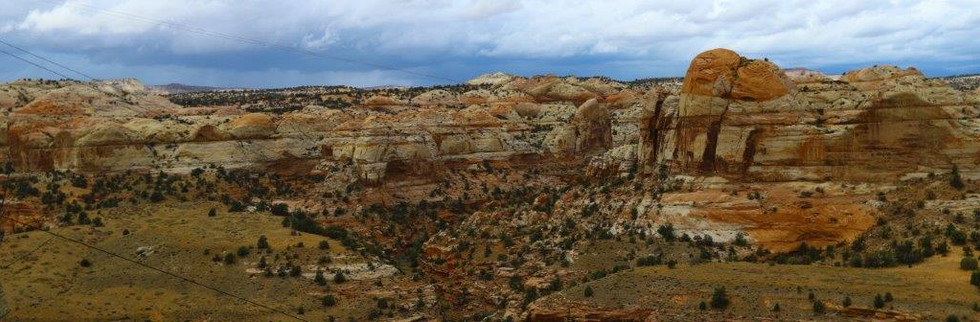
But sometimes the best adventures are born from detours. Reworking the itinerary, I set my sights on a different challenge: biking Highway 12 from Escalante to Boulder — a section often called the most unique and spectacular in the Southwest. The road traverses the Hogback and the aptly named Hell’s Backbone, high ridges where the earth falls away on both sides into slickrock canyons. It would be our biggest adventure of the trip, a two-day out-and-back ride: 45 km each way, with an 867-meter climb. Not long, but tough enough to feel like an achievement.
We packed our bikes in the cool morning air — food, first aid, repair kits, the essentials — and rolled out around 9 a.m. The ride began gently, a steady incline out of Escalante, the quiet broken only by two large groups of cyclists who sped past us downhill, already finished with their day’s challenge. For the next two days, we saw almost no one else on bikes.
Fifteen kilometers in, the incline sharpened, and suddenly we were standing at a high overlook, gazing out at the undulating white-and-red slickrock of the Hogback. Then came the thrill of a steep descent — road signs warning of 8% and even 14% grades — exhilarating but shadowed by the thought of tomorrow’s return climb. Still, on a bike, unlike in a car, the landscape felt alive. The cliffs seemed closer, the air sharper, the scale more humbling.
We paused at the Escalante River overlook, slickrock domes spread in every direction, then rolled down to the Kiva Coffee House. Built from logs in a radial design, its huge windows framed the desert like art. And the cappuccino? The best of the trip — until the one we had there again the next morning.
Then the real work began: the long climb out of the river valley, nearly an hour of grinding uphill. At the summit, a carload of Korean tourists applauded us. Though we shared no common language, one of them pulled out an app that translated in real time. For a few minutes, it felt like we’d stepped into science fiction — a Star Trek communicator in hand, in a landscape that already felt otherworldly.
The rest of the ride carried us along cliffs with dizzying drop-offs, alternating with gentler ascents, until we turned onto Hell’s Backbone Road for the final stretch. Forests replaced desert, and by early afternoon we reached our overnight stop at Boulder Mountain Ranch Lodge. The rest of the day was spent lazily — tossing horseshoes, playing cornhole, strolling to a nearby waterfall — the perfect counterbalance to the morning’s effort.
The next day’s return ride felt almost effortless by comparison. With no uncertainty about lodging or food, we rode at leisure, stopping often to drink in the scenery. The Hogback seemed even more stunning the second time, the feeling of being on top of the world impossible to shake.
As we coasted the last downhill into Escalante, the ride stretched out, but we already knew we’d conquered the hardest parts. Locals at Kiva Coffee House and in town gave us nods of respect when they heard what we’d ridden, along with suggestions for other routes.
By the time we put the bikes away, we were dusty, sore, and smiling wide. What began as a Plan B had turned into the defining adventure of the trip. The Hogsback had given us exactly what the best journeys always do: a mix of challenge, beauty, and the quiet thrill of knowing we’d earned every view.


Burr Trail Wonders: Scenic Red Ridges and Singing Rocks
Following the advice of some locals, we started the morning with breakfast at the Little Bone food truck in Boulder — hearty fuel for a day of exploring. From there, we set out on the Burr Trail, a paved road that winds east out of town into some of the most striking scenery we’d see on the trip.
At first, the road passes through a quiet Boulder neighborhood, then the landscape changes: soft domed white rock gives way to fiery red cliffs. The transition is abrupt and dramatic. Within minutes, we were descending into a canyon that rivaled anything we had seen in Zion — the same glowing walls and sculpted cliffs, but without the visitor center, the shuttle buses, or the crowds. It felt like a private version of a national park.
We stopped at Singing Canyon, a narrow chamber where the sandstone walls act like a natural amplifier. The canyon isn’t long — more of an alcove than a true slot — but the acoustics are real. Standing inside, we could hear even the lightest rustle of leaves magnified into an orchestra.
Continuing on, the road climbed steadily until we reached a high overlook. From there, the view stretched all the way toward Canyonlands National Park — a vast horizon of mesas, ridges, and desert plateaus. We considered continuing along the Burr Trail as it connects through to Notom Road and Capitol Reef, but that way meant long stretches of gravel. With rain in the forecast and memories of our muddy ordeal still fresh, we decided to turn back.
Back on Highway 12, the landscape changed once more. The road between Boulder and Torrey climbs toward 10,000 feet, trading sandstone cliffs for alpine forest. Where we expected sweeping views, we found ourselves wrapped in thick fog instead — another surprise in a trip already full of shifting skies and changing moods. We had now seen these landscapes in nearly every condition: blazing sun, cooling rain, and mountain mist.


Capitol Reef Highlights: Towers, Canyons, and Arches
Arriving in Capitol Reef for the first time, we wasted no time diving into the trails. On our first afternoon, we headed straight for the Chimney Rock Trail. The climb was short but steep, pulling us up to a perch with sweeping views of the park’s signature feature: the slanted, multi-colored “staircase” of rock layers known as the Waterpocket Fold. Reds, yellows, and whites seemed to ripple across the horizon. Later that evening, we stopped at Goosenecks Overlook, where the canyon twists in tight, dramatic curves, and then at Sunset Point, watching the cliffs blaze orange as the day ended.
The next morning was our full day in the park — time to stretch our legs. We started with the Grand Wash to Cassidy Arch, taking the longer approach from Highway 12. The wide, sheer-walled narrows eventually gave way to the steep trail up to the arch itself, where the payoff is as thrilling as it is beautiful: you can actually walk out on top of the stone span, with the canyon dropping away beneath you.
From there, we drove the Capitol Reef Scenic Drive, winding through the heart of the park, each turn revealing another cliff, dome, or canyon. At the end, we explored Capitol Gorge, where 19th-century pioneers carved their names into the rock. A short scramble led us to The Tanks — natural rock basins that collect precious desert rainwater. We were prepared for a swim, but the Tanks were all dry.
On our last morning before the drive to Aspen, we saved one more gem: the hike to Hickman Bridge. The trail winds through slickrock and desert vegetation before suddenly delivering the view — a massive natural bridge framing the sky, elegant and improbable all at once.
For just two days, Capitol Reef gave us a sweeping introduction: challenging climbs, quiet history, and some of the most striking geology we’d seen on the entire trip.


A Whirlwind of Rocks and Trails: Adventure Worn from the Southwest
Two weeks, countless miles, and an endless parade of landscapes later, we finally reached the end of our Southwest adventure. From the towering red walls of Zion to the hidden slot canyons of Page, from the sculpted hoodoos along Highway 12 to the flowing waters of Escalante and Capitol Reef, every day offered a new discovery.
We hiked, biked, and kayaked through places that felt both ancient and otherworldly. Our muscles ached, our feet were dusty, and our hearts full. Each trail, canyon, and ridge demanded attention and effort, but rewarded us with beauty that no photograph could truly capture.
There were moments of complete solitude, like wandering among the Wahweap Hoodoos or threading our way through Willis Creek, and moments of awe shared with the world, like the glowing vistas at Horseshoe Bend or the sweeping panoramas along the Devil’s Backbone.
This journey reminded us that adventure isn’t just about reaching a destination — it’s about immersing yourself fully, letting the landscape shape your day, and feeling the rhythm of exertion and wonder. As we returned home, tired but exhilarated, we carry with us not just images of rock and water, but the deep satisfaction of two weeks spent fully alive in one of the most spectacular corners of the American West.
Practical Information and Route Maps


Sources
Willis Creek Slot Canyon - https://www.visitutah.com/things-to-do/slot-canyons/willis-creek-narrows
Boulder Mountain Ranch Lodge https://bouldermountainguestranch.com/
Boulder Mountain Lodge https://www.hellsbackbonegrill.com/the-lodge
Cycling Scenic Byway 12 https://www.visitutah.com/articles/cycling-scenic-byway-12-escalante-to-boulder
Burr Trail https://www.visitutah.com/places-to-go/cities-and-towns/boulder/burr-trail


Comments