Rafting the Grand Canyon: A Journey Carved in Time
- Ruth Bergman

- Jun 13, 2025
- 15 min read
Rafting the Grand Canyon: Into the Canyon, Into Deep Time
Rafting the Grand Canyon is a bucket-list adventure—one of those iconic trips that linger in the background of your travel dreams until, one day, everything lines up just right. For us, that moment came when we started planning a trip to Havasupai (post on that coming soon) and realized we’d already be in the area. Why not finally make the leap?
The logistics weren’t simple. We wanted to end the trip with our car waiting for us at the South Rim, so we drove up early, left the car at the top of the Bright Angel Trail, and took the Groome shuttle back to Flagstaff. It meant hours of back-and-forth, but the payoff was a preview of the canyon itself—a hazy late-afternoon view from the rim, shoulder to shoulder with tourists from around the world. Unlike them, though, we were heading into the canyon for the week ahead.
We’d booked the 6-day Upper Canyon rafting trip with Outdoors Unlimited, a company recommended by my good friend Jill, who’d taken the same journey a few years earlier. The timing was perfect—the trip started June 2, fitting smoothly into our plans. We chose the Upper Canyon section over the full 14-day descent. Why? Because six days felt like enough—enough camping, enough adrenaline, enough wonder.
That night we met our group at the Americana Motor Hotel in Flagstaff, a playful Route 66 throwback with mid-century vibes and a pool glowing neon blue. Our group was eclectic: ages ranged from 11 to 80, and most were from across the U.S. What we all shared was a sense of anticipation. Our guides walked us through the essentials—how to pack personal gear into dry bags, what to expect on the river, what not to bring. We were told to be ready at 5:30 a.m. for the drive to Lee’s Ferry, the put-in point for all Grand Canyon river trips.
That early morning drive through high desert was its own prelude, with sandstone cliffs and layered mesas hinting at the geologic spectacle ahead. We crossed two bridges—first the Little Colorado River, then the wide green span of the Colorado itself. We were close.
What was I expecting from this trip? Not a physical challenge—the river does most of the work, and the guides the rest. I expected dramatic views, colorful rocks, reflections in still water. I didn’t think much about the geology, about the processes that formed these cliffs or the timescales involved. But as we drifted deeper into the canyon, it became impossible to ignore. The Grand Canyon reveals Earth’s history one rock layer at a time. With every bend of the river, we passed further back through time.


Kaibab Limestone – The Rim and the Beginning
The Kaibab Limestone is a cliff-forming geologic formation dating to the Permian period, roughly 270 million years ago. Composed primarily of fossil-rich limestone and dolomite, it forms the upper rim of the Grand Canyon and stretches across northern Arizona, southern Utah, eastern Nevada, and southeastern California.
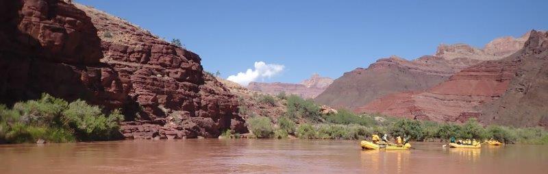
Our own journey into that history began at Lee’s Ferry, the only place for hundreds of miles where the Colorado River can be easily accessed by road. Here, the canyon is still shallow enough to drive to the water’s edge. In the late 1800s, pioneers used this point to ferry wagons across the river; today, it serves as the official launch site for Grand Canyon rafting trips.
We met the rest of our guides at the launch site and got our first taste of river life—gear checks, safety briefings, and an unexpected bit of rafting etiquette: each day, we’d ask permission to board a new raft and ideally rotate among guides. For our first stretch on the river, we joined Travis, with an easy grin, calm confidence and stories from years on the river.
By 10 a.m., we were on the water. June is typically one of the hottest months in the canyon, but the weather had other plans. Clouds gathered overhead, casting soft shadows over the cliffs and bringing the promise of rain. The mood was quiet, anticipatory—muted light, hushed voices, the rhythmic splash of oars.
Soon, we passed beneath the same bridge we’d driven over earlier, now seen from below—already a sign of the shifting perspective this trip would offer. Just beyond the bridge, we spotted a few California Condors hanging on the cliffs. Once nearly extinct, these massive birds are slowly making a comeback in the Grand Canyon.
Above us loomed the Kaibab Limestone, the rim we had left behind just that morning. As we floated forward, we were already drifting backward—into deeper canyons and deeper time.


Toroweap Formation & Coconino Sandstone: Desert Stone and River Calm
The Toroweap Formation and Coconino Sandstone represent the next steps down into the Grand Canyon’s deep past. Both are sedimentary layers, formed around 275–280 million years ago, but they differ in origin and appearance. Toroweap contains a mix of sandstone and limestone, hinting at shifting ancient environments, while Coconino is a clean, pale sandstone formed from vast desert dunes—fossilized wind. Limestone forms from the remains of marine organisms; sandstone from grains of eroded rock. Together, they tell stories of oceans, beaches, and long-lost deserts.
By late morning of our first day, we were fully engulfed by canyon walls, the rim already high above. It was happening quickly—this descent into stone and solitude. With each bend of the river, another layer revealed itself. I found myself compulsively taking photos: of rock faces mirrored in still water, of crumbling textures, of shadows playing on ancient surfaces. Looking up from inside the canyon, the contrasts between layers—color, structure, mood—were far more vivid than anything I'd seen from the rim.
We floated through a handful of easy rapids, just enough to learn the basic position: sit low, hold tight, stay alert. These ones barely required it, but it was good to practice. Around us, five separate trips had launched the same morning. Most faded quickly from sight and sound, except for one raucous private group whose music echoed through the canyon. Their loud pop pulsed in and out with the curves of the river—an odd reminder that even here, solitude could be interrupted.
Because of the crowded river, we stopped early for camp—around 3 p.m. after 12 miles—at Soap Creek, right before the rapid. It is a wide sandy spot, good for camping, and watched over by a herd of bighorn sheep, including several playful young. We had time for a short hike up the wash, to stretch out, and to ease into what our guides called happy hour—an unofficial ritual of snacks, cold drinks, and river conversation.
June usually means hot, dry nights in the Grand Canyon—perfect for sleeping under the stars. But with rain in the forecast, we faced the nightly dilemma: tent or no tent? It was hot, but not stifling. We set up the tent with the rainfly open, hoping for a breeze and prepared for a downpour. Sure enough, it rained that night. In fact, it rained every night except the last. And so we began our journey into deep time with a desert storm, sandstone cliffs, and a sky that couldn't quite make up its mind.


Hermit Shale & Supai Group: Red Walls, Cold Rapids, and Hail from Nowhere
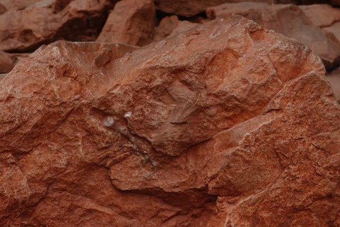
The Hermit Formation, often called Hermit Shale, is a slope-forming layer composed of reddish-brown siltstone, mudstone, and very fine sandstone. It’s not a resistant rock, so it tends to erode into soft slopes rather than sheer cliffs. Beneath it lies the Supai Group, a striking sequence of red beds—sandstone, siltstone, shale, and some limestone—laid down between 290 and 325 million years ago during the Pennsylvanian to early Permian periods. These iconic layers are what most people picture when they think of the Grand Canyon: deep rust-red walls glowing in the light.
We woke to the sound of rapids nearby, and as morning broke, the layered red cliffs of the Supai Group rose steeply on both sides. Our day began with Soap Creek Rapid, moderate in force but enough to deliver a splashy wake-up call at 8 a.m. under a gray, overcast sky. None of us were quite ready to get soaked, but it set the tone: we were in for a wet, cold day of running rapids.
This was the day we rode with Matt, our head guide, and got to witness a true river expert at work. The weather wasn’t cooperating, and every rapid had the potential to throw passengers out of the raft. Between waves, Matt taught us the classic geology mnemonic:
"Know The Canyon's History; See Rocks Made By Time"
(Kaibab, Toroweap, Coconino, Hermit, Supai… and more to come).
We floated through a few more evocatively named rapids—Sheer Wall, House Rock—which sounded more dramatic than they felt, though they still churned up some good whitewater. By late morning we reached North Canyon, a popular side hike into a narrow slot carved into the Supai Group. We pulled on our dry shoes from the communal gear bag and set off. The hike was pure Grand Canyon magic: walking through sculpted, richly colored stone, feeling the textures with our hands and feet, scrambling over natural ledges, and warming up after a chilly morning on the water.
Then it was back to the river, and the weather turned again. As we re-entered a rapid-filled stretch, rain began to fall—gently at first, then steadily, then… harder. Suddenly, I felt something smack my leg. Then my shoulder. Then my head. Hail—marble-sized hail—pelted down on us, stinging wherever it struck exposed skin. In June, no less.
Matt acted fast, pulling us under a protective overhang—an angled ledge of Supai rock that shielded us from the worst of it. We huddled there, laughing in disbelief and marveling at the absurdity of our luck. Later that day, we asked another group in a motorized boat if they’d encountered the hail. “What hail?” they said. For the rest of the trip, we imagined future rafters hearing the tale of that one group who swore they got caught in a hailstorm in the Grand Canyon.
That evening, we landed on a wide beach and peeled off wet clothes as fast as we could. Everyone scrambled into the warmest dry gear we had. The day had delivered extremes—ancient rock, red walls, cold rapids, and a sky full of surprises. It was one for the books.


Redwall Limestone – Cliffs, Caverns, and a Canyon Nearly Lost
The Redwall Limestone is an erosion-resistant, cliff-forming formation from the Mississippian period, about 340 million years old. Despite its name, the limestone itself is actually gray; its imposing cliffs appear red because of staining from overlying rock layers. These sheer walls rise dramatically—between 490 and 800 feet—and are among the most fossil-rich formations in the Grand Canyon.
We woke to another damp morning, rain having fallen through the night. On this narrow sandy beach, we were all camped close. Even the guides, who usually sleep out in the open on their boats, had pitched tarps. But any chill or fatigue was soon swept away by the promise of the day ahead. We were rafting deeper into the signature landscape of the canyon—the towering Redwall cliffs, unmistakable in their scale and grandeur. In places, where the rock wasn’t stained by minerals, we could see its true color: pale gray, surprising and beautiful against the darker red hues.
Our morning brought us to one of the most striking sights of the trip: Redwall Cavern. The river bends gracefully here, hugging the massive Redwall cliffs. As we rounded the corner, we spotted a dark opening in the rock that only grew more awe-inspiring as we approached. Two large motorized rafts were already anchored at the cavern’s mouth, dwarfed by the vastness of the space. The cavern, carved into the limestone by ancient floods, is easily the size of a football field. We pulled in, stretched our legs, and joined the other group for an impromptu game of frisbee on its sandy floor—a surreal playground beneath a ceiling of stone.
Our guide Paul, our raft guide for the day and a geology graduate, led us on a fossil hunt among the scattered rocks. With every step we found more marine fossils perfectly preserved in broken slabs, silent records of life from an ancient sea. Some were so detailed they seemed almost recent—a reminder of just how long this landscape has been taking shape.
We spent the second part of the day with Will on the paddle boat—our young “pterodactyl” who practically grew up on the river. (If you’re unfamiliar with the pterodactyl tradition of river guides, look it up—but be warned: it’s too gross to describe here.)
Later, the river carried us to a sobering chapter in the canyon’s history—the site of the proposed Marble Canyon Dam. We walked through the abandoned tunnels left behind when construction was stopped, a relic of plans to flood this stretch of river for hydroelectric power. By the mid-20th century, the project was well underway. Thankfully, fierce conservation efforts in the 1960s preserved the canyon as we see it today. Stepping from the dark, empty tunnels back into the light—where the red walls rose high around us—it was hard to imagine all of this submerged beneath a reservoir, its beauty and wildness lost under water.


Muav Limestone & Bright Angel Shale: Painted Slopes of an Ancient Sea
The Muav Limestone and Bright Angel Shale are Cambrian geologic formations within the five-member Tonto Group, dating back 504 and 506 million years, respectively. The Muav Limestone is a coarse- to medium-grained, grayish-white, sandy dolomite and fine-grained limestone that forms cliffs and small ledges, weathering to dark gray or rusty-orange. Beneath it lies the Bright Angel Shale—locally fossiliferous, green and red-brown shale and siltstone with occasional sandstone beds—forming gentle slopes along the canyon walls.
This was to be a calm day on the river. We eagerly joined the paddle boat again, glad for the chance to be active. Our guide for the day, Sean—easygoing, athletic, a river guide in summer and ski coach in winter—set a relaxed and confident tone.
As we floated deeper into the canyon and further back in time, a striking color change became visible. The canyon walls were now a mix of gray and green depending on the light, with distinct horizontal textures. My personal favorite layer, Bright Angel Shale, soon appeared, its soft slopes painted with stripes of purple, green, and orange. We were lucky to have a cloudy day—perfect for these colors to show in their full brilliance.
Today held another treat: a classic Grand Canyon hike with one of the most iconic views of the river. As we drifted downstream, we spotted square openings high in the rock face—the Nankoweap Granaries, built by the Ancient Puebloan people (formerly called Anasazi, though this Navajo term is no longer preferred). These ingenious structures supported a migratory way of life, storing corn and seeds in dry, hidden alcoves above the canyon floor.
The short but strenuous climb up to the granaries was well worth the effort. We sat beneath the ancient storehouses, gazing across the canyon’s deep walls where the delta of Nankoweap Creek meets the river. In just a few days, we had traveled through hundreds of millions of years of natural history. On the descent, we stopped at the picture spot—undoubtedly the best photo opportunity of the trip.
We ran a couple of moderate rapids, easily navigated under Sean’s guidance, and soon reached the confluence of the Little Colorado River, where the Grand Canyon proper begins. The rain had denied us some slot canyon hikes, due to flash flood risk, and it turned the Little Colorado’s normally clear blue water into the color of chocolate milk—ruling out a swim. But at the confluence we marveled at the dramatic blending of the Colorado’s clear current with the Little Colorado’s murky brown, watching boils and eddies swirl before the river swept us into another rapid.
Our day ended at the site of one of the worst commercial aviation accidents in U.S. history. In 1956, two airliners—TWA and United Airlines flights—collided mid-air over the Grand Canyon, killing all 128 people aboard. The tragedy spurred the creation of the Federal Aviation Administration. Oren and I wandered in search of airplane remains, but instead stumbled upon another hidden gem: a beautiful slot canyon, offering quiet reflection at the close of an unforgettable day.


Tapeats Sandstone: Ancient Cliffs, Ancient Deltas
The Tapeats Sandstone is a Cambrian geologic formation and the oldest exposed layer of the Tonto Group. About 508 million years old, it reaches up to 70 meters (230 feet) thick. The lower and middle beds of the Tapeats Sandstone are well-cemented and erosion-resistant, forming brownish, vertical cliffs that mark the base of the canyon’s great rock sequence.
We went to sleep beneath an uncertain sky, a rainbow arching overhead, and woke to blue sky and brilliant sun—finally, a typical June day at the Grand Canyon. A welcome change for our last day on the river, one that would bring some of the biggest rapids of the trip.
We joined Paul again and enjoyed both his mastery at the oars and his deep knowledge of the canyon’s geology. We started the day beneath the brown cliffs of Tapeats Sandstone, the river widening here into deltas long used by Native Americans and Ancient Puebloans. With determined rowing, Mark guided us close to a pictograph—a snake-like symbol etched in the rock, a sign of migration.
We made one last stop at an archaeological site where the presence of the Ancient Puebloans was unmistakable. Remnants of buildings divided into rooms stood on the delta, and the ground was littered with clay fragments, some decorated with beautiful stripes—perhaps inspired by the canyon’s own horizontal layers.


Vishnu Schist & Zoroaster Granite: The Basement of Time
The Vishnu Basement Rocks is the collective name for the Early Proterozoic crystalline rocks—both metamorphic and igneous—that form the Grand Canyon’s deepest layers. These ancient rocks underlie the Grand Canyon Supergroup and the Tapeats Sandstone of the Tonto Group. The Grand Canyon Supergroup, visible in only a few areas, dates between 729 and 1,255 million years old, while the Vishnu Basement Rocks themselves range from about 1,375 to 1,840 million years old.
We’re now in the deepest part of the canyon—the Inner Gorge. The walls around us are dense and dark, streaked with striking pink veins of Zoroaster Granite cutting through the black Vishnu Schist. We spot the famous Great Unconformity, where rock layers of vastly different ages meet at odd, jumbled angles. Suddenly, nothing is horizontal anymore. The rock faces tilt and clash, each layer seemingly at odds with its neighbor—a visual reminder of the Earth’s turbulent past.
We stop for lunch on a sandy beach in front of a towering cliff of chiseled rock. Sitting there, I marvel that we’re resting on stones nearly 1.7 billion years old—a humbling perspective that makes the concerns of the present day feel small.
The day ends with a thrill: Hance Rapid, the biggest of our trip. The guides pull over to scout the rapid carefully, checking for changes caused by recent floods or shifting rocks. Their quiet confidence reassures us as we watch them study the water’s course. One by one, our rafts plunge through the rapid—no mishaps, just exhilaration.
That night, in true Grand Canyon tradition, we slept under the stars—no tent needed. I had a few misgivings after joining Sean on a scorpion hunt with his ultraviolet light; scorpions seemed to glow everywhere across the rocks. I’d hoped to catch a glimpse of the Milky Way, but when I woke at 10:22 p.m., the moon was still bright. By the time I stirred again at 4:30 a.m., dawn’s first light was already coloring the sky. No celestial spectacle for me—but I was rested and ready for the climb out of the canyon.


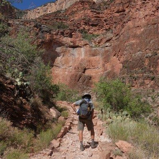
Rising through the Layers: Bright Angel Trail
It’s the last day of our trip, and the mission is clear: hike up and out of the canyon. We’re up early—coffee ready by 5 a.m.—already packed and dressed in our river clothes. The level of organization today would make any military unit proud. Every item has its place; every detail has been considered and optimized. Lunch packed the night before. Gear sorted: what we’re carrying, what stays behind for the next group, what’s bound for goodwill.
We want to beat the heat, so by just after 6 a.m., we’re back on the rafts for a short float to the trailhead. There are no real rapids, yet somehow I’m soaked by the time we land. We change into hiking shoes, bid the guides farewell, and set off.
The hike is long—8 km, all of it uphill. The first stretch is manageable, following a creek that has carved its way through Tapeats Sandstone. We’re climbing back up the rock layers we drifted past for days. The Bright Angel Shale and Muav Limestone are mostly hidden beneath the vegetation. But as we reach the Redwall Limestone, the trail steepens. From here, I count the layers like milestones: just get to the top of the Supai Group, then only a few more to go. The pale Coconino Sandstone wall seems endless. The trail gets more crowded as we near the rim. One final push—and then the Bright Angel gift shop comes into view. We’ve made it. Four hours, forty minutes. Oren isn’t satisfied, but I’m just glad it’s not yet noon.
We did struggle with one of our backpacks—a large daypack borrowed from friends. In hindsight, I realized I’d been too literal with the packing instructions. The rafts could easily have handled our backpacking packs, and even though they’d have been overkill for what we carried, they would’ve been so much more comfortable on the climb.
We reached our waiting car and drove to Seligman, wrapping up the trip as we’d begun it—with a stop at a Route 66 icon. At Delgadillo’s Snow Cap, we devoured ice-cold chocolate shakes—delicious and well deserved.


The Canyon’s Lessons: Rock, Gear, and Inspiration
Every experience is a learning opportunity. On this trip, I learned a little geology—and I was able to feel the passing of millions of years, touching rock that is solid and colorful, yet ever-changing.
There were other lessons too—about gear, for example. I brought what I thought were the perfect river shoes: Keens. Alas, they turned out to be less than perfect. The sole of my right shoe started to separate at Havasupai. I patched it up with Gorilla Glue and duct tape between trips and hoped for the best. But in the canyon, the left shoe gave out. The duct tape didn’t hold against the constant sand and water. Fortunately, I’d packed extra glue and tape, and I was grateful for every day those shoes stayed with me. The lesson? When it comes to critical gear, plan for redundancy.
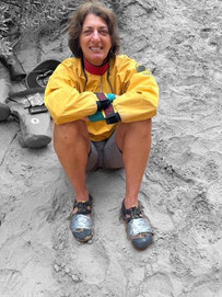
But the most meaningful lesson of all was about living life to the fullest. One member of our group had just celebrated her 80th birthday—her fourth trip through the canyon. She didn’t miss a chance to experience every part of the journey. I snapped a photo of her rowing a raft through a rapid, the guide clinging to the front. May I grow up to be a tough cookie like that.


Resources
Outdoors Unlimited https://outdoorsunlimited.com/
Groome Transportation https://groometransportation.com/grand-canyon/?&sd_client_id=383bc616-e1c6-4a3e-a42d-9422fed761a8
Americana Motor Hotel https://www.americanamotorhotel.com/
Geology of the Grand Canyon, Wikipedia https://en.wikipedia.org/wiki/Geology_of_the_Grand_Canyon_area
Kaibab Limestone, Wikipedia https://en.wikipedia.org/wiki/Kaibab_Limestone
Toroweap Formation, Wikipedia https://en.wikipedia.org/wiki/Toroweap_Formation
Coconino Sandstone, Wikipedia https://en.wikipedia.org/wiki/Coconino_Sandstone
Hermit Shale Formation, Wikipedia https://en.wikipedia.org/wiki/Hermit_Formation
Supai Group, Wikipedia https://en.wikipedia.org/wiki/Supai_Group
Redwall Limestone, Wikipedia https://en.wikipedia.org/wiki/Redwall_Limestone
Marble Canyon Dam, Wikipedia https://en.wikipedia.org/wiki/Marble_Canyon_Dam
Muav Limestone, Wikipedia https://en.wikipedia.org/wiki/Muav_Limestone
Bright Angel Shale, Wikipedia https://en.wikipedia.org/wiki/Bright_Angel_Shale
Tepeats Sandstone, Wikipedia https://en.wikipedia.org/wiki/Tapeats_Sandstone
Vishnu Basement Rock, Wikipedia https://en.wikipedia.org/wiki/Vishnu_Basement_Rocks

Comments