Beyond the Postcard: Backpacking the Grand Teton Crest Trail
- Ruth Bergman

- Jul 22, 2025
- 11 min read
Stepping Into the Postcard: One of America’s Most Beautiful Backcountry Hikes
The United States is home to some of the world’s most stunning natural landscapes—places of scale, solitude, and soul-stirring beauty. And for those of us drawn to the trail, there’s no shortage of epic multi-day treks. From the John Muir Trail in California to the Appalachian Trail in the East, these long-distance routes promise immersive journeys through wild places.
But when I asked a few seasoned hikers to name the most beautiful trek in the country, one answer came up more than once: the Grand Teton Crest Trail. Not the longest, nor the most famous—but in terms of sheer alpine beauty, it earned the top spot. That was all I needed to hear. I added it to my list of active adventures for the year.
Like many visitors, I had been to Grand Teton National Park before. I’d seen those unmistakable peaks rising above the flats, stopped at roadside pullouts and picnic areas, and even camped beneath the towering range. But, like most, I had never entered the mountains themselves. I had admired the postcard view. What I hadn’t done—until now—was step into it.


Before the Trailhead: Getting There and Getting Around
Grand Teton National Park feels like two different parks. Down in the flats—at Jenny Lake, Colter Bay, and Jackson Lake—you’ll find full parking lots, buzzing ranger stations, boat rentals, and well-stocked general stores. This is the familiar face of the Tetons, where most visitors stay firmly rooted to the valley floor, looking up. But beyond the front country, deep in the peaks, lies a different world—one without cell service, signage, or amenities. This is the backcountry, and it’s where we were headed.
That shift from postcard to wilderness carries a few implications. First: permits. Backcountry camping in the Tetons is tightly regulated, and demand is high. I made our reservations on Recreation.gov just days after the system opened for 2025—and still had to patch together what I could get: Fox Creek Pass, Alaska Basin, and an outlier site in Paintbrush Canyon. Not ideal, but I figured I’d adjust once we arrived.
And I did. At the ranger station—after picking up our bear canister and watching the sobering backcountry safety video (a rite of passage for all overnight hikers)—we met with a ranger to review our route. He warned us about Paintbrush Pass: the snow hadn’t fully melted, and the steep slope on the east side was “treacherous.” We adjusted our itinerary: Marion Lake for night one, and North Fork Cascade for night three. That way, we could approach Paintbrush Pass with the option to retreat if conditions were too risky. It also avoided crossing two high passes in a single day, which the ranger strongly advised against. But it left us with a very long final day—and the possibility of missing our shuttle. Bottom line: we were carrying some concern as we set off.
The full Teton Crest Trail runs about 40 miles, so trailhead logistics take some planning. Oren insisted we skip the 4,000-foot climb at the start and take the Aerial Tram from Teton Village—an efficient (and scenic) way to get high fast. We flew in and didn’t rent a car, which complicated things. Uber works around Jackson and the airport, but not reliably inside the park. We used an expensive but reliable taxi to get to Teton Village early in the morning, and at the end of the trail, caught the lodge shuttle from Jenny Lake after enjoying a celebratory beer. It all worked out, but only because we spent time thinking it through.
We stayed at Colter Bay the nights before and after the trek—honestly, because it was the only place with availability when I booked in June. Like much of this trip, the logistics were a little pieced together. But in the end, they gave us exactly what we needed: a way into the wild.


Into Bear Country: Where Beauty and Solitude Sooth Our Concerns
Our journey began with a scenic drive from Colter Bay to Teton Village. Early morning light poured over the valley, and a herd of bison lounged in the fields—an iconic sendoff. We wound our way down the Moose-Wilson Road, where dense forest closed in on both sides, and arrived at Teton Village just in time for breakfast. Cowboy Coffee Co. delivered an excellent cappuccino and a warm, filling breakfast sandwich—a last luxurious bite of civilization before heading up into the mountains.
At the Aerial Tram, we stood out from the crowd with our hiking boots and heavy packs. Most riders were there for the view or waffles at the summit. We were there to disappear into the Tetons. As we soared up to 10,000 feet, the world opened beneath us—forests, valleys, and the long ribbon of the trail ahead.
The first day of a long hike always requires an adjustment. The pack felt heavy—because it was. I was carrying the bear canister and all the food, and my shoulders knew it. We were on high alert for bear safety: one bear canister, and food spilling into overflow bags we promised ourselves we’d consolidate after dinner. We clipped on our bear bells—though, honestly, who knows if they help, checked on our single can of pepper spray (not ideal), and set out.
Thanks to the tram, the hike itself wasn’t difficult. Just six miles to Marion Lake, mostly flat or downhill. But between the pack weight and the sudden gain in altitude, even the short uphill stretches felt like a slog. The trail wandered through alpine meadows and boulder fields, always with views stretching out toward granite peaks above and the valley floor below.
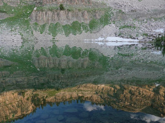
We reached Marion Lake around 2 p.m. and gratefully dropped our packs. The designated campsites were tucked away from the water. It was a stunning spot, framed by sharp ridgelines and opening toward distant valleys. We watched the sun go down, the moon come up, and the lake mirror the rocks above in the stillness of evening.
If not for the biting insects, it would’ve been a perfect night. Flies, mosquitoes, midges, no-see-ums—we lost count. We wore nets and long sleeves, but they still found skin. I finished the trip with bites all over my face and hands. A reminder that the wild belongs to the wildlife.
After dinner, I began the nightly bear canister puzzle. With some creativity (and a bit of denial), I managed to cram in all the food. Toiletries? Left outside. “Not really food for bears,” we told ourselves. In the morning, I checked—no sign of disturbance. No bears, no marmots. Just crisp mountain air, a reflective lake, and a trail leading on.


Above the Trees: Traversing Death Shelf and Alaska Basin
We began the morning with a short ascent to Fox Creek Pass—shorter than expected, which was a happy surprise. From the pass, the views were expansive. The jagged peaks of the Tetons stood impossibly close, and deep canyons carved the landscape in every direction. It felt like we had stepped onto a high balcony above the world.
Soon after, we saw signs for Death Canyon, and the trail delivered us to its namesake shelf. “Death Shelf” sounds ominous, but in truth, it’s a gift: a broad, gently sloping bench that allows hikers to skirt the steep canyon below. Instead of plunging down and climbing back up, we traversed along the canyon wall, high above the trees.
Midway along Death Shelf, we heard a deep, rolling thunder. But the sky was a flawless blue. We scanned the horizon and spotted a massive rockslide crashing down the opposite canyon wall—a plume of dust rising in its wake. A glance at our own slope, with its similar rock formations, sent a jolt of adrenaline through us. We quickly agreed on a rockslide plan: duck behind the largest boulder we could find. It was a sobering reminder that this landscape is alive and shifting.
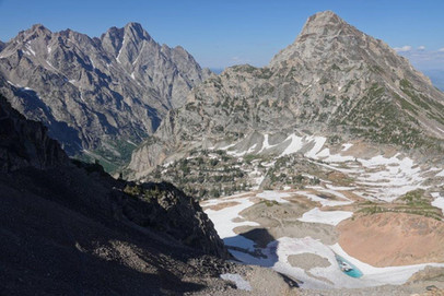
We reached Meek Pass not long after. Another short climb, another stunning reveal—this time, the wide expanse of Alaska Basin. Rock walls and ridgelines stretched outward like a natural amphitheater. Snow lingered near the pass, but only in scattered patches, easy to cross. We took a long break here, legs resting and spirits lifted by the sheer scale of the terrain.
By afternoon, we began our descent into the basin, passing a turnoff for Mirror Lake. Tempting, but half a mile off-trail—we kept moving. Soon we were climbing again, working our way up the far side of the basin. It was the toughest ascent so far. Our goal was to get as close as possible to the next high pass before calling it a day.
When we reached the sign for Sunset Lake, it felt like fate. The lake was tucked beneath towering cliffs, its still surface reflecting the golden hour light and the ridge above. A small stream tumbled from the lake, offering ice-cold, crystal-clear water—deliciously crisp. We arrived by 4 p.m., with hours of sunlight left to relax. We soaked our sore feet in the chilly water, cooling off instantly after the long haul. Sunset Lake lived up to its name, in beauty and in serenity. An ideal place to spend the night—resting, recharging, and wondering what tomorrow might bring.


The Long Haul: Conquering Fear and Fatigue on Paintbrush
I woke early and stepped out to enjoy the soft light of morning. Then came our usual camp routine—coffee, oatmeal, packing up. It always takes longer than we think. We didn’t hit the trail until 9 a.m.
We were bracing for a hard climb up Hurricane Pass, but it turned out to be easier than expected—gentler than the haul up from Alaska Basin the day before. At the top, Cascade Canyon opened up before us, ringed by rugged granite ridges. For the rest of the day, we’d follow the water: down the South Fork, then up the North Fork, marveling at the endless string of waterfalls and cascades.
The trail up the North Fork brought us back into day-hiker territory. We passed several groups and paused to ask backpackers about conditions on Paintbrush Pass. We were still on the fence—rangers had warned us about snow and steep exposure—but a passing hiker told us the snowfield had been trenched and was no longer treacherous. Encouraged, we kept going.
Our permit had us camping in the North Fork Cascade zone. We reached the upper edge of the zone around 3 p.m., but with the sun still high and our legs feeling strong, we decided to push on. We knew this meant tackling Paintbrush Pass today, but we were ready.
We reached Solitude Lake soon after. Solitary it was not—clearly a favorite day-hiking destination—but for good reason. The lake sat in a bowl of high ridges, a natural amphitheater of stone and sky. The trail curved around its turquoise waters before beginning the final climb.
The hike up to the pass was deceptive. Instead of tight switchbacks, the trail traversed across the mountainside in one long, continuous arc. When we finally began to zigzag again, we were already worn down. Still, we were committed. We trudged upward and reached the top just after 5 p.m., too late to linger.
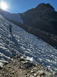
The descent was where we finally understood the warnings. Though the trail itself wasn’t steep, it crossed a sheer mountainside—a place where one misstep could send you sliding a long way down. At the top, a large patch of snow covered the trail. We stepped carefully into the trench that previous hikers had carved. It helped—tremendously. But it was still nerve-wracking, especially crossing an exposed section of rocks between two snowfields. At the end of the snow, the trail resumed—four feet below. I sat down and slid.
Snow wasn’t the only hazard. The upper part of Paintbrush Canyon was steep, loose, and tiring. We finally donned our micro-spikes for better footing on the remaining icy patches. It took another hour to descend before we reached the Upper Paintbrush camping zone.
Here, for the first time, campsites weren’t marked. It took a little exploring, but we found a quiet spot tucked among the trees and set up camp around 7 p.m. Nine hours of hiking—it was the most we’d ever done in a single day. We were exhausted but relieved. The hardest day was behind us, and we were now well ahead of schedule for our shuttle.
There was still daylight left to savor. We sat high above the canyon, watching the sun caress the peaks as it set, listening to water tumbling through the rocks below, and toasting the day’s success with a well-earned happy hour.


Light on Our Feet: Descending with Confidence
Thanks to pushing over Paintbrush Pass the day before, we could now take our time. It was another relaxed morning at camp, savoring our last coffee in the backcountry. A deer wandered nearby—a welcome change from the many marmots we'd been seeing.
We set off down the canyon, taking a detour to Holly Lake, a serene alpine lake tucked among the ridges. At this early hour, we had it to ourselves. The descent continued, revealing glimpses of the flats far below, and distant views of the large lakes—Jackson Lake, perhaps—between the canyon walls.
As we dropped lower, the forest thickened and we began to see more day hikers. Spotting our large packs, many stopped to ask what we were doing. We proudly told them we were finishing the Teton Crest Trail. They seemed impressed—or so we liked to think.
The final miles were flat and easy. The terrain and vegetation had completely changed. Soon we reached String Lake, busy with kayaks and paddleboards, a world away from the alpine stillness we’d left behind. Before long, we were at the trailhead. We did it.
We still need to get back to Colter Bay, which starts by waiting for a shuttle at Jenny Lake Lodge. We had a delicious IPA made by a local brewery and were served by the nicest bartender imaginable. We couldn’t stop talking about the decision to push over Paintbrush Pass the day before. It had felt uncertain in the moment—risky, even—but it turned out to be exactly the right call. Because of that choice, our final day on trail had been smooth and unhurried, filled with small joys: a quiet alpine lake, a curious deer, a conversation with fellow hikers, and the satisfaction of walking ourselves all the way out. There’s something powerful about ending a big effort with ease rather than exhaustion. No scrambling, no racing the clock. Just confidence in our legs, peace in our minds, and the chance to savor the finish line.


Trail Truths: No Shortcuts, No Regrets
Another world-class trek under our belts. Another active adventure checked off the list. This was my third backpacking trip of the year—and while there’s nothing I love more than time in the backcountry, I’m not in a rush to hoist a heavy pack again anytime soon. That particular truth hit me hard somewhere near the top of Paintbrush Pass.
And yet, I wouldn’t change a thing.
Skipping that last stretch—opting to exit early at Cascade Canyon—would have left the journey unfinished. Paintbrush was the final challenge that made the trail feel complete. I’m deeply grateful that my resolve held steady, and even more grateful that the snow cleared just in time for us to safely cross. The payoff was more than just a panoramic view or the satisfaction of a hard push—it was the quiet pride of seeing something through.
I’m thankful for the beauty we witnessed: sunrises over alpine lakes, peaks brushed with late-day light, wild terrain unfolding in every direction. I’m thankful, too, for the wildlife we encountered—mostly marmots and mosquitoes—and for the wildlife we didn’t. No bear sightings this time, and that’s perfectly fine with me.
There’s a simple truth that every long trail teaches in one way or another: there are no shortcuts to the finish line. Whether it’s up a high pass or through a tough day, you walk every mile with your own feet. And if you’re lucky, you walk it with strong companions, good humor, and just enough grit to keep going.
On the trail, like in life, resolve and perseverance are what carry you through. And when you arrive—tired, dusty, content—you carry more than a pack. You carry the trail with you.


Hiking Maps


Day 1 July 8 Aerial Tram to Marion Lake 11.08 km 3:39:16 moving time 410 m elevation
Day 2 July 9 Marion Lake to Sunset Lake 15.03 km 4:31:40 moving time 556 8 elevation
Day 3 July 10 Sunset Lake to Upper Paintbrush 21.50km 6:45:34 moving time 1167 m elevation
Day 4 July 11 Upper Paintbrush to String Lake 11.73 km 3:05:38 moving time 37 m elevation
Resources
Grand Tetons Crest Trail, Clever Hiker, https://www.cleverhiker.com/backpacking/teton-crest-trail-backpacking-guide/
Backcountry Camping Routes and Zones, National Park Service, https://www.nps.gov/grte/planyourvisit/backcountryroutesandzones.htm
Backcounry Permits and resservations. recreation.gov
Cowboy Coffee Company https://cowboycoffee.com/locations/teton-village/
Jackson Hole Arial Tram https://www.jacksonhole.com/summer-activities/summer-tram
Grand Teton Lodge Company https://www.gtlc.com/
Grand Teton Lodge Guest Shuttle https://www.gtlc.com/activities/complimentary-guest-shuttle


Comments